Welcome to Maps Printer’s documentation!
Even though multiple pages and atlas options have improved print layouts usability and help enough to create many maps with few print layouts in a project, you can still have many print layouts in your project. And when comes the time to print or export them, it is not as fun as it could be. You indeed need to open each print layout, wait till it renders, fill the export options, wait till the export finishes to open the next layout. And so on…
If you find this process long and somehow boring (and even if you do not), then Maps Printer plugin is designed for you. It offers an easy, simple and quicker way to export print layouts to pdf, svg or image (jpg, tif, png, bmp…) file format.
Installing
The easiest way to install Maps Printer plugin in QGIS is through
the Plugins --> Manage and Install plugins... menu of QGIS.
Using Maps Printer plugin
When installed, Maps Printer adds to the Processing Toolbox a new Maps Printer
entry with following algorithms:
Export layouts from project: exports a set of layouts from the current projectExport layouts from folder: exports all the layouts from all the projects files in a selected folder
A Help entry is also added to the top Help --> Plugins --> Maps Printer menu
and opens this documentation.
Custom settings
From the Processing options dialog (Settings --> Options -->
Processing -->), under Providers --> Maps Printer, you can
select the default format you wish to use while exporting.
The list of available formats is based on the one supported by your OS.
Export layouts from project
Once you have created and set at your convenience your print layouts and wish to export some of them,
-
Expand the
Maps Printerentry in theProcessing Toolboxpanel and double-clickExport layouts from project. The following dialog opens.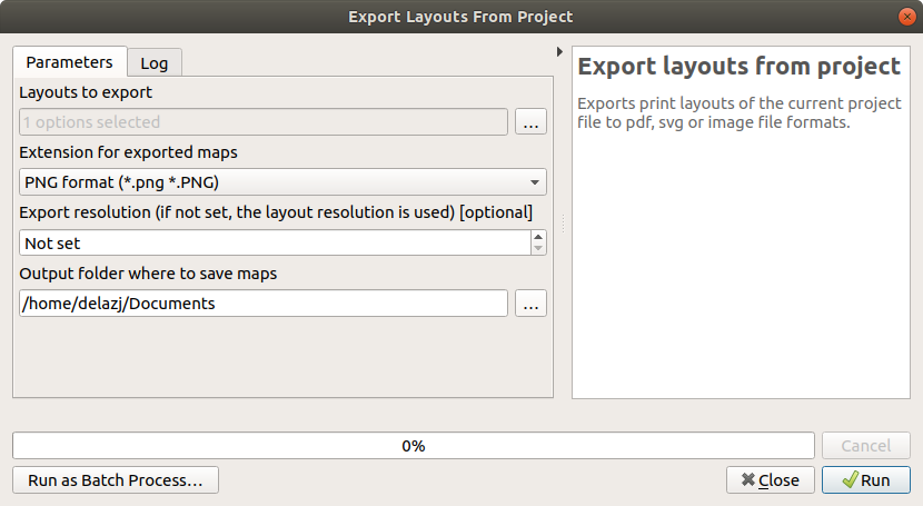
The Export from Project algorithm dialog
- Click the
...next to theLayouts to exportfield. - Check the print layouts from the list that opens, validate.
- Select the file format to use in
Extension for exported maps. By default, its value is set to.pngformat but you can configure it (as explained below). - Enter a custom
Export resolutionto apply to all the outputs. If not set, each layout is exported using its own set resolution. - Press the
...button ofOutput folder of exported mapsto browse your file explorer and select the output folder -
Click
Runto execute.Maps will be output to the indicated folder. Check the log tab for issues, if any.
Export layouts from folder
The Export layouts from folder algorithm helps you export layouts
from projects in a folder.
-
Expand the
Maps Printerentry in theProcessing Toolboxpanel and double-clickExport layouts from folder. The following dialog opens.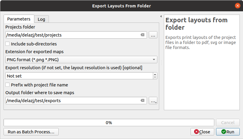
The Export from Folder algorithm dialog
- Click the
...button of theProjects folderfield and select the folder to use as input - Check the
Include sub-directoriesoption if you want to also export layouts from the subfolders of the input director - Select the file format to use in
Extension for exported maps. By default, its value is set to.pngformat but you can configure it (as explained above). - Enter a custom
Export resolutionto apply to all the outputs. If not set, each layout is exported using its own set resolution. - With many files (containing many layouts) being exported to the same directory,
you can hit filename collision.
Check
Prefix with project file nameto minimize the risk; exported layouts will will be placed following the project folder structure. - Press the
...button ofOutput folder of exported mapsto browse your file explorer and select the output folder -
Click
Runto execute.QGIS will successively open each available project file and output their layouts’ maps.
From command line
Maps Printer’s algorithms can be run from the QGIS Python console:
 # Display help, for algorithm parameters
 >>> processing.algorithmHelp("mapsprinter:exportlayoutsfromproject")
 # Export few layouts to PDF
 >>> processing.run("mapsprinter:exportlayoutsfromproject",
         {'LAYOUTS': [0,2],
         'EXTENSION': 0,
         'OUTPUT': '/path/to/exports/folder'
         }
     )
Starting from QGIS 3.14, it’s also possible to call Maps Printer’s algorithms and export layouts from the command line using qgis_process.
 # Display help, for algorithm parameters
 $ qgis_process help mapsprinter:exportlayoutsfromfolder
 # Export layouts from project files within a folder and subfolders
 $ qgis_process run mapsprinter:exportlayoutsfromfolder --PROJECTS_FOLDER=/path/to/projects/folder \
   --RECURSIVE=1 --EXTENSION=0 --OUTPUT_FOLDER=/path/to/exports/folder
Plugin developped by Harrissou Sant-anna (CAUE 49) - 2021